You are currently browsing the monthly archive for January 2014.
The sign on the road into Dartford welcomes you to “Historic Dartford”. Unfortunately this market town is about to have its historical heart ripped out and all to make way for a new Tesco superstore. The shops in Lowfield Street are about to be demolished. Richardson’s butchers is one of the few shops still opened but a notice went up this week. After 104 years in the same shop it will be closing down 8th February.
Let me tell you a little about this small family butchers. It has been selling locally sourced meat to the Dartford community since 1908. When I ordered a goose, this Christmas, Ray Richardson (the current owner) advised me to walk around the back of the shop where there is some open land. There I could see the geese roaming freely. The chickens they sell are raised on local farms and are more flavoursome than anything Tesco could provide, even from their “Extra” range. At one time there were other shops in the street each with their unique offer but a planning process that’s taken eleven years as blighted the area.
There are two reasons I am dismayed about events. Firstly, the thought of every town looking exactly the same and with the same dull offer is just limiting. There’s little point in visiting different places. Secondly, we should cherish old buildings especially in an historic market town. They are probably better built than anything planned. Take a look at the drawings for the new Dartford Tesco here dull and from the same architectural stable as the Woolwich store. Note the claims that the anchor store is going to drive business in the rest of the town. Well not according to one of the leading retail academics and Government adviser Professor Alan Hallsworth:
“I categorically do not accept that any superstore of any size can be dumped into a small market town and no damage will ensue.” Read full article here.
Dartford is an old market town and its charter dates back to James ll. The Royal Victoria and Bull Hotel dates back to 1703 and it is still a pub with accommodation. There is a space further down the High Street where the Le Bell public house stood which dated back to 1507 but was sadly demolished in 1962.
An information board here titled One Town that Changed the World cites interesting facts such as Dartford was the first town to use gas lights. All that needs to be added is that there was once a fine parade of Victorian shops in Lowfield Street.
The massive stone piers of the The Herbert Pavilions ,with ornamental lamp-holders, at the entrance leaves you in no doubt that this was an important building. In its time it was a futuristic building, as it was the first hospital in the country to have the Pavilion design influenced by Florence Nightingale. A large block, which was the administrative building fronts on to Shooters Hill.
Behind are seven two-storey pavilions at right angles to the road. In the central pavilion a grand staircase leads to a large chapel. At one time there was a bust of Florence Nightingale made by disabled servicemen at the Kidbrooke Rehabilitation Centre. Take a look at this postcard of the patients’ dining area. Oh how standards have changed!
Situated on the corner of Shooters Hill and Well Hall Road it was originally the army’s Herbert Hospital opened November 1865. It became the Royal Herbert Hospital following a visit by Queen Victoria 22nd March 1900.The Queen visited the Royal Arsenal in the morning and then proceeded to the hospital. She was accompanied by her third daughter Helena (Princess Christian of Schleswig-Holstein) and her grand-daughter the Young Princess Victoria. The entrance to the hospital was decorated with flags and they were met by the Principal Medical Officer Lieutenant Colonel Bourke. The Royal party stayed for well over an hour talking to convalescing soldiers. In line with Victorian sensibilites the Royal party were sheltered from the seriously injured men.
The hospital closed 25th June 1977 and was, thank goodness, saved from demolition by a Local and English Heritage listing. In 1990 the site was bought by a developer and converted into apartments. Its lost the title of hospital and is now known as the Herbert Pavilions.
A little way down Shooters Hill, just back from the main road is the old Brook Hospital. It opened in 1896 as a “fever hospital”. It wan’t until I came across Lowry’s painting The Fever Van that I realised what a scurge scarlet fever was in the early C20th. The painting shows an ambulance collecting a fever victim and the community coming out to watch. The painting shows the pain of the whole community as the prospect of return was very slim indeed. During the First World War the hospital became an additional military hospital with some beds reserved for prisoners of war. It is now apartments.

The water tower that serviced the hospital has been converted into a “Grand Design” dwelling which has been empty for sometime. Shooters Hill was once known as the “street of hospitals” because of these and the Memorial Hospital further up the hill and of course the animal hospital opposite the Fox under the Hill.
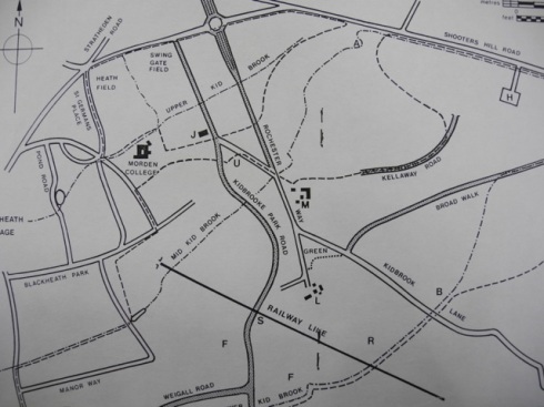
It wouldn’t take a genius to guess that Kidbrooke takes its name from a stream but, like me, you may be surprised to learn that there are three brooks all called Kid – Lower, Upper, and Mid. Although looking at the street names on the Brook Estate should have been a clue that there is more than one stream. Today, the streams are mainly underground in culverts and only surface here and there.
The streams flow in a south westerly direction and are tributaries of the River Quaggy which in turn flows into the Thames. The Quaggy had been buried for over 50 years under Sutcliffe Park, so most people living in the area didn’t know it existed. It,like the Kid Brooks, was erased from the collective community memory. These streams and rivers have since been called lost urban rivers. In 2003 the Quaggy was daylighted which is the term used to describe the restoration of river. Allowing the river to assume its natural state helps to reduce the risk of flooding in built up areas as well as providing a wetland habitat for wildilfe. It has also enabled some of the new development at Kidbrooke Village to be marketed as having a river view.
This marshy land was home to some of the last farming communities in South East London. There were four farms: Kidbrooke, Upper Kidbrooke, Lower Kidbrooke and Kidbrooke Hill. The Express Dairy stopped farming here in 1937 and the land developed for housing, industry and the military.
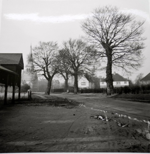
The old photographs of the area show clearly the land was prone to flooding. When the Royal Herbert Hospital was being built in the mid C19th, on what was Kidbrooke Common, builders battled with flooding and subsidence. By 1881 serious subsidence was evident in the chancel of St James’ Church in Kidbrooke Park Road and it had to be rebuilt.
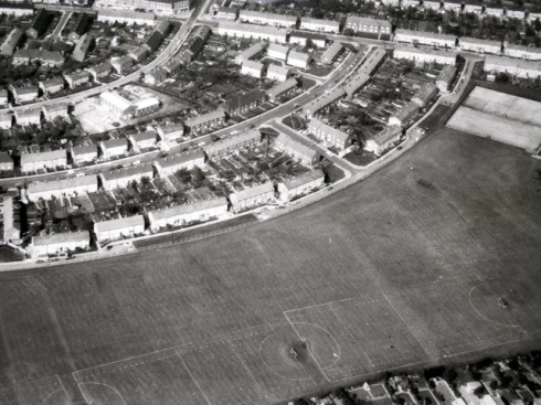
The 1970 aerial photograph shows the corridor of green, now sports fields, that follows the path of the Lower Kid Brook. One of the fields belongs to The Samuel Montagu Youth Centre, named after the City of London Banking business of the same name. One of the world’s strangest sports, Chessboxing, started here in the 1970s by brothers James and Stewart Robinson. It’s now an international, fast growing sport that combines a round of boxing followed by a game of chess.


